|
|
Post by Yeast on Jan 10, 2006 10:02:37 GMT -5
Airport Hilton just west of I95 on Southern.
Exit I95 at Southern in West Palm Beach and go west.
Turn almost immediately into the Hilton and look for screaming hashers in the back.
|
|
|
|
Post by Anal Inspector on Jan 18, 2006 12:59:22 GMT -5
Hey, Ride Me & Mist Her Volunteed at the on after last week
|
|
|
|
Post by Ex-Presidente on Jan 19, 2006 9:45:11 GMT -5
I think it is Hey Ride Me solo or perhaps with Dirty Dick ButtKiss.
|
|
|
|
Post by Yeast on Jan 19, 2006 9:55:58 GMT -5
Yes how right you are, CA, she told me last night that he will be playing softball, so we may not see much of MistHerBush with them Wed night ballgames
PS: let us know about the ballgame hash, speaking of balls.......
|
|
|
|
Post by Yeast on Jan 23, 2006 13:20:53 GMT -5
Prediction Map (yes it IS a long trail, almost 6 miles, but our hare IS a marathoner now !) ;D tinyurl.com/9ru8y |
|
|
|
Post by threeandahalf on Jan 24, 2006 10:38:13 GMT -5
Here's my prediction. When you look at the map, remember that a large part of the area on the east side of I-95, between Southern and Belvedere, is a bulldozed former neighborhood. Perfect for hashing. Also, the park south of Southern and east of I-95 is great trail. And finally, the railroad track on the west side of I-95 has been prime hashing area in the past, although I'm not sure what shape it's in since all of the construction. Looks like I'm going for the over this time. 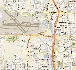  |
|
|
|
Post by Hay Ride Me on Jan 24, 2006 12:14:31 GMT -5
The hash will be hared by Hay Ride Me and Dirty Butt Kiss. We will be starting from the NW corner of the PB Hilton's parking lot, basically behind the hotel near the airport and the water.
|
|
|
|
Post by Ex-Presidente on Jan 24, 2006 13:29:29 GMT -5
Here's my prediction (superimposed over 3 1/2's cause it's kind of similar). DirtyButtKiss, feel free to steal this trail from me. I, too, am predicting the over (/under I95) and my trail also uses that bulldozed shiggy ex-community where the streets still show on the map. But my trail goes under 95 at Summit and over 95 at Southern. Too close to Dreyer Park not to use it I say. I also have some poorly written arrows and a beer check which fellow predictors are not men enough to show.  |
|
|
|
Post by threeandahalf on Jan 24, 2006 14:22:03 GMT -5
Do I need to start putting copyright symbols on these prediction maps? I'm always concerned about protecting my content.
That's not a bad prediction. But I'm sticking with mine.
Perhaps the hares will surprise us with a lap around the airport, a la Anal Inspector.
|
|
|
|
Post by SuckMeDry on Jan 24, 2006 14:34:20 GMT -5
Not to take away from Anal laying a long trail but it was EatMeAlive that ran us around the airport, exactly 7 miles.
He used that trail as his 7 mile bridge training run.
|
|
|
|
Post by Ex-Presidente on Jan 24, 2006 16:49:02 GMT -5
I remember running around the airport when EatMeAlive hared. He was training for his one and only seven mile bridge run and his trail was exactly seven miles around the airport. It was long and boring. HeyRideMe and ButtKiss wouldn't do that to us... would they?
Sorry about stealing your map 3.5 but my guess was relatively close to yours and it saved me a few minutes of Yahooing a map of the area. Though it wouldn't be a bad idea to use the same map. Each of us could write in a different color.....
Btw I was going to use that airport land east of i95 last spring but actually had trouble getting in. There's a really tall fence around it now. Maybe Wilma helped the situation.
(PS That map program Yeast uses does not work well with Windows 98 Explorer apparently. I see part of the map and when I try to adjust it, it knocks me out of my session totally).
|
|
|
|
Post by threeandahalf on Jan 26, 2006 8:52:20 GMT -5
HayRideMe and DBK did a pretty good trail last night.There was a pretty good turnout, perhaps 20 people. Even Bootlicker showed up. We were all glad to hear that he is drinking again. I rode my bike because it was so close to my house. Circumspector was kind enough to bring my hash shoes and a dry shirt in her car. There had been a lot of speculation about how the trail would go, and we were all anticipating a good one. My prediction had the trail going north, and crossing I-95 at Belvedere, while Yeast and CA both had it going south and crossing at Summit. HayRideMe and DBK took their head start, GH counted down 12 minutes, and the pack surged as one.  We hit a couple BTs and CBs, but the pack mostly stayed together. All three predictions were quickly shot down, mine more so than the others. The first beer stop was at the Clubhouse Pub, who has seen us once or twice before. AC/DC got there on his hog, but the other walkers arrived on foot shortly after us. Apparently it was okay for us to stand outside on the sidewalk with our beers. I think I was up to 4.7 miles or so at that point. .jpg) .jpg) The second half was more of the same. Still well executed, although nobody fell for the wrong-way-pointing arrows that one of the hares (probably DBK) kept throwing. The pack kept a fast pace, and pretty soon we found ourselves at the second beer check, which was a stash of beer hidden by a canal. I had forgotten my flash, so I got this shot of P-rick with my new technique of shining my flashlight in his face. I think I need a bigger flashlight. Once the beer was gone we got moving again, and flew through the last third of the trail. .jpg) I had the high mileage, with 7.47 miles. I did a lot of bad trails and CBs. Yeast ran the circle, and did a good job. He never really lost control. And there was enough beer. We finished up quick, because the overpass back over I-95 was going to close at 10 pm for construction, and that's how you get to the bar. I skipped the bar and rode my bike home in the rapidly dropping temperatures (oooh, 50 degrees, so cold). Before I left, I got this picture of AD and PS, by illuminating them with the bike light. That's them lit up with 10 watts of 6 volt power. .jpg)
|
|
|
|
Post by Yeast on Jan 26, 2006 9:52:45 GMT -5
And NGB wants to know, is that building in the background of the shot with AD and PS the jail or is it the Hilton ?
Yeast (Never loses control of the circle (maybe?))
|
|
|
|
Post by Yeast on Jan 26, 2006 9:57:40 GMT -5
Cum Again, here is where you can upload your Garmin GPS log file to (the XML file) and have the website map out the actual trail for you, its Google map powered, not that M$ stuff  www.gpsvisualizer.com/map?form=forerunner www.gpsvisualizer.com/map?form=forerunner |
|
|
|
Post by threeandahalf on Jan 26, 2006 10:03:04 GMT -5
That is in fact the Hilton. You can tell it's the Hilton because the jail doesn't have any big neon sides on the side. The jail doesn't have to advertise; they get plenty of business already. I have heard the jail referred to as the "Crossbar Hotel", though. And I hear they have the best bologna sandwiches in town there.
Obviously it would be a better story for AD and PS to tell people that it is the jail, and she was just there bailing him out after he was arrested for solicitation of a male prostitute.
Umm, I just remembered that last night I signed up to lay trail. I think it's in two weeks. Time to start scouting!
|
|


